November 6, 2008

Perito Moreno

Perito Moreno


Perito Moreno is one of the biggest natural spectacles of the world. It is located in Las Glaciares National Park in the south west of Santa Cruz province, Argentina. Perito Moreno is a 250 square kilometers glacier, 30 kilometers long, 5 kilometers wide and 80 meters high above the water. This icefield is the world's third largest reserve of fresh water and it is the only glacier in the world to be still growing. It was named after the Argentine explorer, Francisco Moreno, who played a great role in securing Argentina's territory in the conflict with Chile regarding the international border issue. 

Like all glaciers, this one begins high in the mountains, (in this case - the Andes), which separate Argentina from Chile. At the source, snowfall is nearly constant, and the weight of all this snow compresses the lower layers into virtually solid ice. As the snowfall continues, gravity pushes the thick mass of ice outward—downhill in this case. So a glacier is basically the same as a river, except that the water is frozen. This river moves very slowly about one meter per day from its source roughly 30km away. As it descends, it encounters higher air temperatures and begins to melt. Some glaciers melt into the ocean; this one melts into a lake. The end of the glacier is a sheer wall of ice about 5km (3 miles) long and standing 60m (200 feet) above the water’s surface. When pieces fall off (a process known as calving), they make a tremendous roar and splash. Every 3 to 4 years the ice breaks and it is a fantastic natural performance not to be missed.

October 12, 2008

Perce Rock

Perce Rock


Perce Rock is one of the largest and most spectacular natural arches in the world. Its an island and sheer rock formation in the Gulf of Saint Lawrence in Quebec, Canada. Famed for its extraordinary natural beauty, it is a popular tourist destination and is an important Bird Sanctuary. Bounded  by sheer russet-colored cliffs, the rock is 1,420 feet (433 meters) long. From a height of 288 feet (88 meters) on the landward end, its top slopes down to 160 feet (49 meters) at the offshore end. The rock gets its name from a large 15 metre (50 ft) high arch near its seaward end. 
Perce Rock does not stand alone. Just beyond it is a smaller rock, the Obelisk, also pierced by an arch. Standing still farther offshore is the much larger mass of Bonaventure Island. Bounded by cliffs 300 feet high, its top is virtually inaccessible to all but the seabirds that flock there to nest. Herring gulls and cormorants are the most numerous nesters on Perce Rock. And amoung the birds that swarm over Bonaventure Island is the largest colony of gannets in North America. 

September 10, 2008

Autumn Colors

Autumn Colors One of the greatest shows in the natural world takes place every year in the forests of eastern Canada and the United States, as turning leaves paint the landscape spectacular colors from yellow, to orange, to deepest red and purple. How do leaves change color? - Leaves are nature's food factories. Plants take water from the ground and a gas called carbon dioxide from air. They use sunlight to turn water and carbon dioxide into glucose (this process is called photosynthesis), which they use as a food for energy and as a building block for growing. A group of pigments present in the leaf that helps the photosynthesis to happen and gives the leaf a green color is called chlorophylls. During the growing season, the plant replenishes the chlorophyll so that the supply remains high and the leaves stay green. In the late summer, the veins that carry materials from the leaf to the branch and minerals from the roots into the leaves are closed off as a special layer (cork cells) forms at the base of each leaf. It is during this time that the chlorophyll begins to decrease and disappears completly in relatively short time period.

autumn colors
This is when autumn colors are revealed. As the bright green fades away, we begin to see yellow and orange colors. These colors are present in the leaf throughout the growing season but are not visible as they are covered up by the green chlorophyll. In some trees like, maples, glucose is trapped in the leaves after photosynthesis stops. Sunlight and the cool nights of autumn cause the leaves turn this glucose into a red color. The brown color of trees like oaks is made from wastes left in the leaves.

August 27, 2008

Aurora Borealis - Northern Lights

Northern Lights


Auroras are natural colored light displays in the sky, which typically occur in the ionoshere and are seen particularly in the polar region. They are the nature's own fireworks, apparently dancing across the dark sky. Aurora Borealis originate from sun. During large explosions and flares, huge quantities of solar particles (plasma clouds) are thrown out of the sun into the deep space. When these solar particles are closing in on earth, they are captured by earth's magnetic field and are guided towards Earth's two magnetic poles ( north pole and south pole). Down towards these magnetic poles, the solar particles are stopped by Earth's atmosphere. There they collide with the atmospheric gases present and the collision energy between the solar particle and the gas molecule is emiited as a photon (light particle). Thus, many such collisions causes an aurora.

Aurora Borealis
The auroral lights' colors are determined by the spectra of gases in the Earth's atmopsphere, and the height at which the most collisions take place. Incoming particles tend to collide with different gases at different heights. Thus the green light occurs at the altitudes of 120 to 180 km, red light occurs at even higher altitudes, while blue and violet occur mostly below 120 km. The most common auroral forms and structures are Homogeneous arc, Arc with ray structure, Homogeneous band, Band with structure, Corona, Curtain etc.

For more information visit: http://www.northern-lights.no/english/what/index.shtml

August 6, 2008

Lake Assal

Lake Assal 


Lake Assal is a crater lake, located at the southern border of Tadjoura Region. It lies 155 meters below sea level and is the lowest point in Africa. Lake Assal has no outlet, streams flow into the lake and not away from it.
Lake Assal sits at the top of the Great Rift Valley in the Danakil Desert where summer temperatures sometimes reach 52 degree celsius and are accompanied by strong drying winds. It has a high evaporation rate. The air temperature is very high. Strong winds cause further evaporation. All this evaporation leads to an increasing concentration of salt in the water, making the lake a mineralized brine that is the saltiest body of water in the world. The surrounding plain, once the lake floor, is a glistening expanse of salt. During each wet season the lake level rises, and as the water slowly evaporates, another band of salt is laid down on the plain. In the southeastern part of the lake, small fish inhabit the springs, but if they are accidentally carried out into the main part of the lake, they die at once. Transported by the waves, their bodies are thrown onto the plain, rapidly covered with salt and thus preserved.

July 11, 2008

Uluru

Uluru 


Uluru, also referred to as Ayers Rock, Northern Territory, Australia, is believed to be the world's largest free-standing rock. It is made of sandstone and measures 335m high, 3.6m long and 2 kilometer wide. The rock was formed more than 450 million years ago from horizontal layers of soft sands deposited on an ocean floor. Subsequent movements of the earth's crust upended the formation, turning the layers to a vertical position. The projecting remnant of a mountain that was once much larger was whittled to its present size and contours by long periods of wind and water erosion. The differences in the hardness of the upturned layers of sandstone have caused them to erode in different rates, resulting in the pattern of ridges and furrows across the surface of the rock.

The rock is composed of arkose, a course-grained sandstone rich in the mineral feldspar. Depending upon the atmospheric conditions and the time of the day, the rock can dramatically change color, anything from blue to violet to glowing red. During sunset the rock glows red and during rainy seasons the rock acquires a silvery-grey color, with streaks of black algae forming on the areas that serve as channels for water flow. Large caves are most numerous near the base of the rock. They have been used since time immemorial by the Aborigines, who decorated their walls with paintings and pictographs.

July 1, 2008

Pitcher Plant

Pitcher Plant


Pitcher plants (or pitfall traps) are carnivorous plants with leaves adapted for trapping insects. These plants grow in places where the soil is thin or poor in nutrients such as nitrogen and phosporous. Each leaf forms a "pitcher", a tubular shaped enclosure, usually containing a liquid. The insects which are attracted by nectar and sometimes by the brilliant coloration are prevented from climbing out by deflexed bristles and is drowned in the fluid. The small bodies of liquid contained within the pitcher traps are called phytotelmata. They drown the insect, and the body of it is gradually dissolved. Through a mechanism of digestion, the prey items are converted into a solution of amino acids, peptides, phosphates, ammonium and urea, from which the plant obtains its mineral nutrition (particularly nitrogen and phosphorus).

Carnivorous Plant
Its leaves and structure are expertly formed to survive and regardless of its conditions, the pitcher plant remains resilient, adaptable, and beautiful. Many of its species and hybrids, are cultivated as novelties for their large and showy pendent pitchers.

June 27, 2008

White Sands

White Sands White Sands National Monument includes the most scenic part of the world's largest gypsum dune field and is located in southern New Mexico. The sand, as white as snow, is composed of fine crystals of gypsum, the same mineral from which plaster of paris is made. The source of the sand is the San Andres Mountains to the west of the basin and the Sacramento Mountains to the east. Both mountain ranges contain massive deposits of gypsum that was formed as an ancient sea evaporated some 100 million years ago. In a process that has gone on for countless centuries, seasonal rains and melting snow carry dissolved gypsum from the mountains down to lake Lucero in the lowest part of the basin.
In this harsh desert environment, the water soon evaporates and leaves a glittering crust of gypsum crystals on the lake bed. Weathering and erosion eventually breaks the crystals into sand-size grains that are carried away by the prevailing winds from the southwest, forming white dunes. The dunes constantly change shape and slowly move downwind, covering the plants in their path. Constantly on the move, the dunes advance upto 33 feet per year.
The gypsum does not readily convert the sun's energy into heat and thus can be walked upon safely with bare feet, even in the hottest summer months. Here and there, however, drought-resistant plants such as salt bush and yucca manage to survive. Here too are found highly specialized pocket mice, lizards, and other creatures whose white coloration makes them nearly invisble on the gleaming gypsum sand.

June 19, 2008

Giant's Causeway

Giant's Causeway Giant's Causeway, is an extraordinary grouping of steplike basalt columns some 75 miles across the sea coast on the edge of the Antrim plateau in Northern Ireland. The tops of the columns form stepping stones that lead from the cliff foot and disappear under the sea. Altogether there are 40,000 of these stone columns; some of them have four, five, eight, or even ten sides, but the majority are perfect hexagons ranging from 15 to 20 inches in diameter. Viewed from above, the columns look exactly like paving stones, all neatly fitted into place.
This striking landscape was caused by intense volcanic activity, which brought large amounts of molten basaltic lava to the surface. The molten lava cooled at a slow, very even rate. And as it cooled, the lava gradually contracted, forming prismatic patterns in the cooling rock. As cooling and shrinkage continued, the cracks on the surface extended through the entire lava mass to form a network of vertical joints seperating the flat-sided basaltic columns. Giant's Causeway is a National Natural Reserve, declared a World Heritage site by UNESCO, and is the most popular tourist destination in Northern Ireland. Similar assemblages of basaltic columns are found in many other places, but few can rival the precise geometry of those making up the Giant's Causeway.

June 12, 2008

Seashells

seashells
A shell is a part of a sea creature known as mollusk. Mollusks are wormlike creatures and exist in the ocean, fresh water and also on land. The main characteristic of mollusks is that they dont have internal skeleton. Their shell serves as an exo-skeleton and protects them from the outside world. The shells are primarily composed of calcium carbonate, which is secreted by the outer surface of the mantle of the shell and are loosely attached to the animal body.
The food consumed by mollusk causes pigments to be produced within the mantle and based on this pigment secretion the outer shell's color and shapes are formed. If the pigment secretion is continuous, spiral or radial lines are formed. If the pigment secretion is periodic, then spots appear on the shell. When the mollusk dies, its shell is the one part that typically remains intact. Seashells are very often found in beach drift, which is deposited along strandlines on beaches.

June 7, 2008

Pamukkale

PamukkaleFrom a distance the fantastic rock formations of Pamukkale (meaning "cotton castle" in turkish) in southwestern Turkey resemble a castle built of snow and ice. Tier upon tier, the dazzling white ramparts and parapets descend for more than 300 feet down a rugged mountainside. On closer inspection, however, the steplike series of overlapping basins looks more like a gigantic waterfall petrified by some mysterious, awesome force of nature. The strange rocks of Pamukkale are the improbable handiwork of hot springs.

Farther up the mountainside springs bubble from the earth, issuing a stream of water with a
temperature of about 43 degree celsius and very high concentration of dissolved mineral salts. The water has been flowing down the slope, cooling, evaporating, and depositing the dissolved minerals. Bit by bit, the walls of the many stepped rocky terraces and basins took their present form. For centuries the spring water has been prized for its therapeutic properties. In ancient times the Romans built a thermal resort, Hierapolis, nearby.

June 5, 2008

Strokkur

StrokkurEver since medieval times, Iceland has been famous for its many hot springs and geysers. Although the Geysir's performance has become less impressive in recent times, dozens of other hot springs continue to bubble and spurt in the same thermal area in southwestern Iceland. Amoung the most active and predictable in the group, located in a valley at the foot of a range of volcanic mountains, is Strokkur, the "churn". Every 4 to 10 minutes it shoots a jet of boiling water as high as 100 feet into the sky.


geyserFluctuations in the water level in its basin herald each eruption. As the turbulence increases, the surface of the water heaves up into a dome, then explodes into a cloumn of steam and water droplets. The clouds of vapour blow away on the breeze, but the water falls back to the basin to contribute to the next eruption. The abundance of geysers is due to Iceland's geological history. In this volcanically active zone, molten magama lies close to the earth's surface, where it heats underground water and powers its periodic eruptive escapes through fissures in the crust.

June 3, 2008

Eisriesenwelt

EisriesenweltThe mysteries of Eisriesenwelt were not discovered until 1879. Subsequent exploration revealed that the cave system extends over a total distance of some 26 miles (42 Kilometers). Eisriesenwelt - the "world of the ice giants" - is the largest ice cave in the world. Much of the interior of this cave system high in the Austrian Alps is filled with the fanciful forms of stalactites and stalagmites similar to those found in other caves. But here the contours seem to be more fluid and the colors more translucent. The reason is: The underground formations are composed not of minerals but of ice.
 
Since the temperature in the cave remains at or near freezing all year round, water dripping from the ceiling solidifies into immense icicles, similar to stalactites. Drops falling to the floor freeze, to form spirelike stalagmites. In some places ice stalactites and stalagmites have joined into large floor-to-ceiling fluted pillars. Currently about 200,000 tourists come here every year. The cave with its entrance perched 3,300 feet above the valley floor, is accessible by cable car. Beyond the entrance visitors discover an artfully illuminated, shimmering fantasyland of ice sculptures on a mammoth scale.

May 30, 2008

Bucegi Mountains

Bucegi Mountains 


The Bucegi Mountains cover 115 square miles (300 square Kilometers) of the renowned Transylvania region of Rumania.The mountains' history dates back about 100 million years to the time when sandstone, shale, conglomerate, and limestone began forming in this region, which marks the boundary of two major crustal plates. Within the Bucegis lie sinkholes and caverns, while strange rock formations rest upon the slopes. This variety in landform results from the rocks differing degrees of resistance to water and wind erosion. Where limestone predominates, water may dissolve it, forming sinkholes and caverns. Where conglomerate and sandstone prevail, the harsh wind and weather may cut peculiar shapes - for example, Sphinx and Babele.

Glaciers and rivers also modeled the Bucegi terrain. At the head of some of the highest valleys, glacial ice chiseled semicircular hollows known worldwide as cirques. Rivers have carved the mountains, creating deep ravaines and gorges. Within the Bucegis is a national park, a preserve for the extraordinarily diverse plant and animal life found there.

May 20, 2008

Angel Falls

Angel Falls 


In the year 1935, an American pilot-adventurer, Jimmy Angel, saw the falls for the first time from his plane while exploring the wilderness of Venezuela's Guiana Highlands in search of gold. He found immortality instead.

The waterfall that bears his name is spectacle of extraordinary beauty. Spilling over the edge of a reddish white sandstone escarpment, the jet of gilstening white water knifes downward and dissolves in a frenzy of spray in a dark green jungle setting. The water first plummets in a single unbroken cascade of 2648 feet (807 meters), hits an obstruction, then hurtles down for another 564 feet (172 meters). With a total drop of 3212 feet (979 meters). The height of the falls is so great that before getting anywhere near the ground, the water is buffeted by the strong winds and turned into mist. Often shrouded in mist and pelted by rain, the plateau is known by its Indian name of Auyan Tepui ("Devil's Mountain"). Angel Falls is the tallest waterfall in the world. From the top of the escarpment to the foot of the gorge, the waters plummet for a distance equal to nearly 20 times the height of Niagara Falls.

Angel Falls is one of the Venezuela's top tourist spots, but even today, a trip to the falls is a very complicated one. The falls are located in an isolated jungle of Venezuela, and a flight from Puerto Ordaz  is required to reach canaima camp, the starting point for river trips to the base of the falls. River trips generally take place from June to December, when the rivers are deep enough for the wooden curiaras used by the Pemon guides. During the dry season ie. from December to March there is less water seen than in any other months.

For more amazing pictures visit   Angel Fall pictures.

More information about the travel, stay and tour packages can be found in http://www.salto-angel.com/

for more info: Wikipedia

May 16, 2008

Balancing Rocks

Balancing Rocks


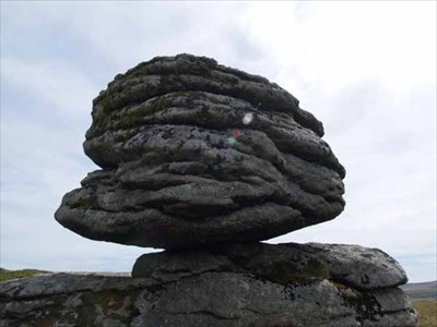
With a history that stretches back 3 and half billion years, the enormous formations that make up the Balancing Rocks are the one among the oldest wonders on the planet. The rocks appear to be so precariously balanced, one on top of another, that even a light push could send them rolling down into the surrounding scrub. But as the thoushands of tourists who have tried can testify, no shove can dislodge the Balancing Rocks. They sway, but they never fall.

How do these rocks balance? Time, Climate, erosion and the structure of the rock give the answers. The rocks were once part of the earth's crust. The crust is mainly granite, which originally lay molten deep within the earth. Over millennia it gradually rose toward the surface, cooled, shrank, and cracked in such a way as to produce a series of massive granite blocks that were more or less rectangular. As time passed, groundwater seeping in through the cracks weathered these blocks and eventually rounded off the once angular corners. After the rocks became exposed on the surface of the land, the sun, wind and rain completed the rounding-off process. Daily heating and cooling helped flake off the surface layers already loosened by water, wind and rain carried away the debris. Thus, once-solid mass of granite has eroded into a heap of giant boulders, some poised at such delicate angles that a hand can rock but never dislodge them.