May 30, 2008

Bucegi Mountains

Bucegi Mountains 


The Bucegi Mountains cover 115 square miles (300 square Kilometers) of the renowned Transylvania region of Rumania.The mountains' history dates back about 100 million years to the time when sandstone, shale, conglomerate, and limestone began forming in this region, which marks the boundary of two major crustal plates. Within the Bucegis lie sinkholes and caverns, while strange rock formations rest upon the slopes. This variety in landform results from the rocks differing degrees of resistance to water and wind erosion. Where limestone predominates, water may dissolve it, forming sinkholes and caverns. Where conglomerate and sandstone prevail, the harsh wind and weather may cut peculiar shapes - for example, Sphinx and Babele.

Glaciers and rivers also modeled the Bucegi terrain. At the head of some of the highest valleys, glacial ice chiseled semicircular hollows known worldwide as cirques. Rivers have carved the mountains, creating deep ravaines and gorges. Within the Bucegis is a national park, a preserve for the extraordinarily diverse plant and animal life found there.

May 20, 2008

Angel Falls

Angel Falls 


In the year 1935, an American pilot-adventurer, Jimmy Angel, saw the falls for the first time from his plane while exploring the wilderness of Venezuela's Guiana Highlands in search of gold. He found immortality instead.

The waterfall that bears his name is spectacle of extraordinary beauty. Spilling over the edge of a reddish white sandstone escarpment, the jet of gilstening white water knifes downward and dissolves in a frenzy of spray in a dark green jungle setting. The water first plummets in a single unbroken cascade of 2648 feet (807 meters), hits an obstruction, then hurtles down for another 564 feet (172 meters). With a total drop of 3212 feet (979 meters). The height of the falls is so great that before getting anywhere near the ground, the water is buffeted by the strong winds and turned into mist. Often shrouded in mist and pelted by rain, the plateau is known by its Indian name of Auyan Tepui ("Devil's Mountain"). Angel Falls is the tallest waterfall in the world. From the top of the escarpment to the foot of the gorge, the waters plummet for a distance equal to nearly 20 times the height of Niagara Falls.

Angel Falls is one of the Venezuela's top tourist spots, but even today, a trip to the falls is a very complicated one. The falls are located in an isolated jungle of Venezuela, and a flight from Puerto Ordaz  is required to reach canaima camp, the starting point for river trips to the base of the falls. River trips generally take place from June to December, when the rivers are deep enough for the wooden curiaras used by the Pemon guides. During the dry season ie. from December to March there is less water seen than in any other months.

For more amazing pictures visit   Angel Fall pictures.

More information about the travel, stay and tour packages can be found in http://www.salto-angel.com/

for more info: Wikipedia

May 16, 2008

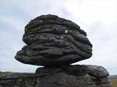
Balancing Rocks

Balancing Rocks


With a history that stretches back 3 and half billion years, the enormous formations that make up the Balancing Rocks are the one among the oldest wonders on the planet. The rocks appear to be so precariously balanced, one on top of another, that even a light push could send them rolling down into the surrounding scrub. But as the thoushands of tourists who have tried can testify, no shove can dislodge the Balancing Rocks. They sway, but they never fall.

How do these rocks balance? Time, Climate, erosion and the structure of the rock give the answers. The rocks were once part of the earth's crust. The crust is mainly granite, which originally lay molten deep within the earth. Over millennia it gradually rose toward the surface, cooled, shrank, and cracked in such a way as to produce a series of massive granite blocks that were more or less rectangular. As time passed, groundwater seeping in through the cracks weathered these blocks and eventually rounded off the once angular corners. After the rocks became exposed on the surface of the land, the sun, wind and rain completed the rounding-off process. Daily heating and cooling helped flake off the surface layers already loosened by water, wind and rain carried away the debris. Thus, once-solid mass of granite has eroded into a heap of giant boulders, some poised at such delicate angles that a hand can rock but never dislodge them.